

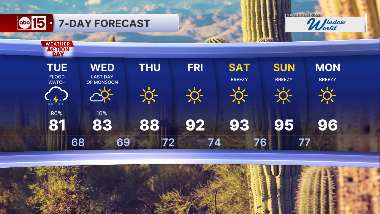


PHOENIX — It's a wet start to the week across Arizona, and Monday and Tuesday are ABC15 Weather Action Days.
Rain and thunderstorm chances are ramping up as a storm system moves in from the west, with moisture from Hurricane Polo and the remnants of Odalys streaming in from the south.
- WHAT TO EXPECT: Heavy rain and flash flooding possible across Arizona
- LIVE RADAR
- FULL WEATHER SECTION
- CURRENT TRAFFIC CONDITIONS
Seeing storm activity in your area? Send your best weather photos and videos to share@abc15.com.
Track the latest updates from this storm system below:
10:15 a.m.
- At approximately 8:10am
- N 327th Dr. / Tonopah Salome Hwy. Tonopah Az
- Upon arrival, E328 (AFMA) found one silver Tacoma on its side with one patient on top of the truck.
- The patient was approximately 30 feet from the shoreline.
- Arizona Fire and Medical called for assistance from MCSO helicopter
- Patient lifted from vehicle by MCSO helicopter crew
- Patient transported to hospital for further evaluation
- No firefighter or civilian injuries reported
7:20 a.m.
Officials in the area of 10th Street and Dove Valley Road say only one vehicle was swept away in the floodwaters and no one is missing or in need of assistance.
6:45 a.m.
Service Update: Flooding in Phoenix is causing delays of up to 60 minutes on northbound and southbound B line trains. A line trains do not have significant delays at this time. Please check the Valley Metro app for updated arrival times. #vmservice #phxtraffic
— Valley Metro (@valleymetro) September 29, 2026
6:10 a.m.
Crews are in the area of 10th Street and Dove Valley Road, where at least two vehicles have reportedly washed away in floodwaters, the Maricopa County Sheriff's Office says.
"It appears one subject was able to make it safely out of one vehicle, however, there may be a subject still in another vehicle. Deputies and fire personnel are on scene attempting to locate the vehicle," MCSO says.

5:40 a.m.
The FAA says Sky Harbor flights are delayed due to thunderstorms in the area.

5:30 a.m.
🌧️We are seeing rain throughout the state this morning.🌧️
— Arizona DOT (@ArizonaDOT) September 29, 2026
Please slow down. Avoid driving through pooling water pic.twitter.com/7mAifjzQNv
5 a.m.
Need sandbags? Here are resources and places to get them in Mesa, Pinal County, and Chandler, Phoenix, Scottsdale, and Gilbert.
4:15 a.m.
No major power outages are impacting Valley SRP customers right now, but the APS outage map shows about 500 customers without power in parts of the West Valley.
3:50 a.m.
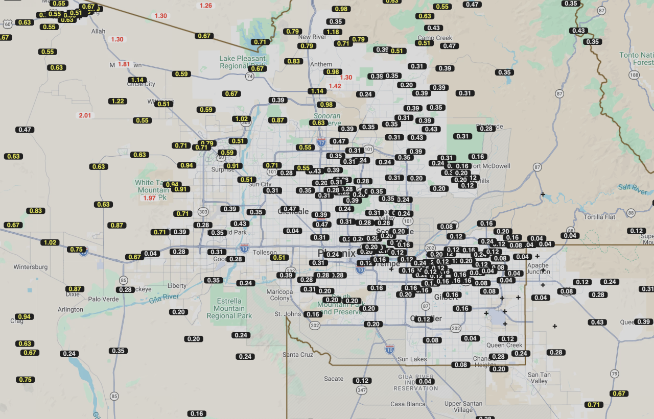
Rainfall totals around the Valley over the last 24 hours range from a trace to an inch or more, according to the Flood Control District of Maricopa County.
See some of the rain totals over the last 24 hours:
3:03 a.m., Tuesday
A special weather statement has been issued for Peoria AZ, Surprise AZ and Sun City AZ until 3:45 AM MST pic.twitter.com/OJ7kwZgqln
— NWS Phoenix (@NWSPhoenix) September 29, 2026
11:40 p.m., Monday
11:40 PM MST Radar Update: Showers and isolated thunderstorms are beginning to fill in across south-central and southwestern AZ. Coverage will continue to expand late tonight and into early Tuesday morning. Flash flooding will be the main threat. #azwx pic.twitter.com/TV2aOfVnol
— NWS Phoenix (@NWSPhoenix) September 29, 2026
8:25 p.m.

1:40 p.m.
Scottsdale residents should prepare for heavy rain, flooded roads and fast-rising washes as multiple rounds of storms move through the area Monday night and Tuesday. The city is under a Flood Watch from midnight Monday through 9 p.m. Tuesday, Sept. 29.
Heavy rain can quickly fill the Indian Bend Wash and close unbridged crossings, including Roosevelt Street, Osborn Road, Murray Lane, Oak Street at 77th Street, Medlock Drive, Starlight Way, Jackrabbit Road, Pecos Lane and the Safeway Plaza entrance north of Chaparral Road along Hayden Road. Other areas that frequently flood include Scottsdale Road north of Loop 101 and Pima Road north of Pinnacle Peak Road. Residents should watch for standing water, debris and damaged pavement throughout the city.
Stay out of flooded washes and drainage channels and keep children and pets away from moving water. Trails and parks may also close. Before visiting a city park, Scottsdale’s McDowell Sonoran Preserve or another recreation area, call the city’s information line at 480-312-3111 to check for weather-related closures.
Scottsdale Emergency Management is monitoring conditions and coordinating with Fire, Police and other partners. The city will provide updates if conditions change or warnings are issued.
Free sandbags available while supplies last.
Residents can pick up complimentary sand and bags at two self-service locations:
McKellips Police District, 7601 E. McKellips Road
Solid Waste Transfer Station, 8417 E. Union Hills Drive
Both locations are available 24 hours a day on a first-come, first-served basis. Shovels are provided, but residents must fill their own bags. There is a limit of 10 bags per household. Fill bags one-half to two-thirds full and place them where water could enter a home, such as in front of doors and garages.
Residents should continue to monitor weather forecasts and official city updates as the storms develop.
10:45 a.m.
10:33 a.m.
The SRP outage map shows about 1,200 utility customers without power in the Valley.
The APS outage map shows there are approximately 300 utility customers without power in the Valley.
10:30 a.m.
The FAA says there are departure delays impacting Phoenix Sky Harbor International Airport, averaging 15 minutes (and increasing) due to thunderstorms.
8:30 a.m.
🌧️We're seeing rain moving through parts of the West Valley🌧️
— Arizona DOT (@ArizonaDOT) September 28, 2026
🚗Please slow down and allow for extra braking room.
🚗Use headlights
🚗Avoid driving through pooling water pic.twitter.com/pM1icyMTzh
7:35 a.m.
